Using LLMiHpt to Optimize the Design of a Permeable Reactive Barrier
Over 300 years ago Alexander Pope said “a little knowledge is a dangerous thing”. In the case of many subsurface characterization programs being completed today, too little data is also a dangerous thing. It can result in wasted time, energy and money. This article presents a case study showing how a combined Low Level Membrane Interface Probe and Hydraulic Profiling Tool (LLMiHpt) survey allowed one client to spend the same amount of money, but actually end up with a Permeable Reactive Barrier (PRB) that worked.
Understanding the complexities of a problem is often easier said than done in the environmental industry. Lithology, permeability and contaminant distribution are all major variables that can change rapidly in all directions across a site. Traditional drilling and sampling programs provide the basic, necessary data, but the approach can be very inefficient, often requiring multiple rounds of work and once done, the total amount of data obtained is quite small. Subtle changes in the subsurface can be missed when using this traditional approach alone. Limited site characterization data requires assumptions to be made to fill in data gaps, leaving room for error and, ultimately, an incomplete or even inaccurate understanding of subsurface conditions. The result is often that too little knowledge is available, even after a lot of effort has been spent.
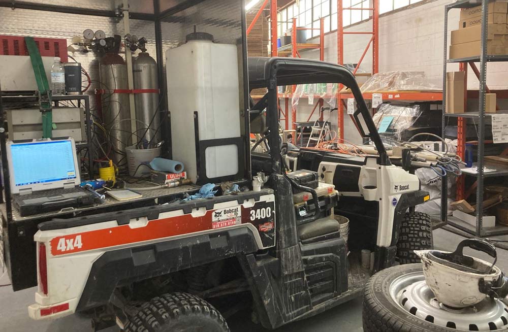
LLMiHpt Deployed on-Site at interior location
Vertex was retained to deploy High Resolution Site Characterization (HRSC) technologies on-Site to quickly and accurately fill in data gaps for the PRB design. The LLMiHpt, deployed using a Geoprobe® drill rig and was able to collect massive amounts of data on electrical conductivity (EC), soil permeability, and contaminant concentration and types using a single push of the probe. The thousands of data points are collected and displayed by depth in real time while standing on-site.
The LLMiHpt survey was completed along a property boundary and several interior locations down to depths of 9.7 m (32 ft) where a plume of chlorinated solvent contaminated groundwater was flowing onto the client’s property from an off-site source. Prior to completing the LLMiHpt program the PRB design for the site was based on only three monitoring wells and analytical data from a limited number soil and groundwater samples. The PRB was to be about to 80 m (260 ft) in length along the property line and from 1 to 4 m (3 to 13 ft) in depth. The objective of the LLMiHpt survey was to identify more accurately the geologic, hydrogeologic and contaminant characteristics along the property boundary to refine the PRB design in the hopes of saving the client money.
Chlorinated solvent impacts were detected along most of the property boundary, however, the furthest points of the LLMiHpt program indicated that the outer edges of the groundwater plume had been identified. Similarly, the LLMiHpt was able to delineate the depth of the contamination impacting the client’s property (Figure 1).
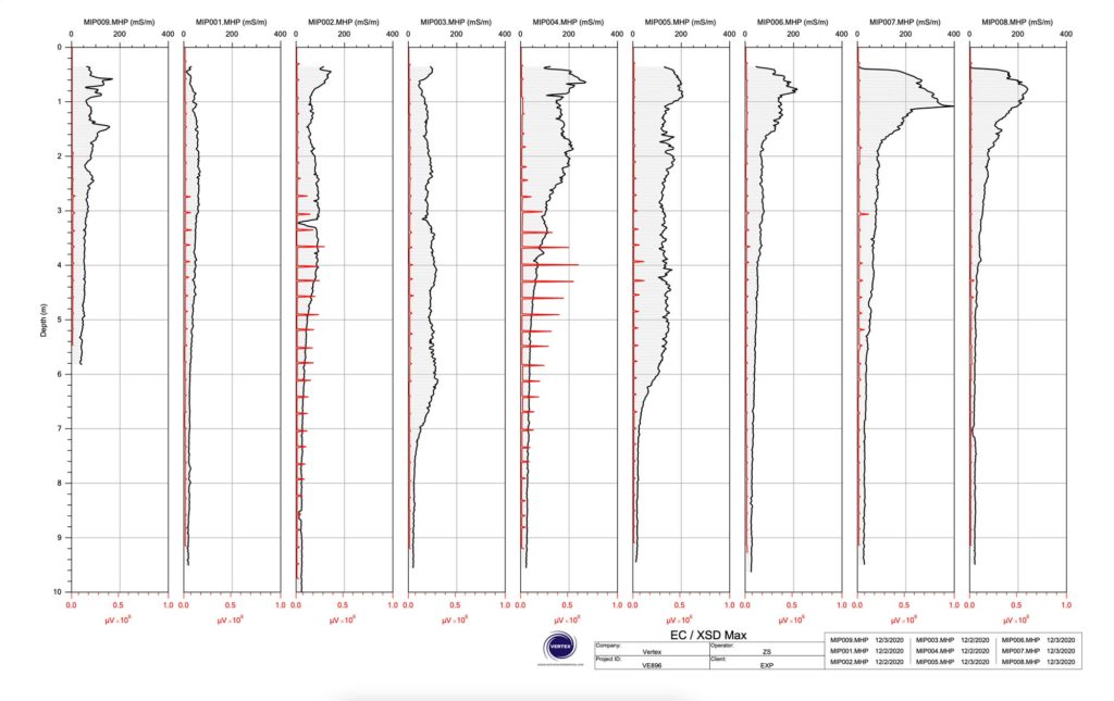
Figure 1 – EC and XSD Responses from the LLMiHpt Points Along the Proposed PRB Alignment
Based on the results of the LLMiHpt program, the total required length of the PRB was significantly shortened from the original 80 m down to 55 m along the property line. However, if the PRB has been installed based on the limited information originally available, there would have been a significant portion of the deeper chlorinated solvent plume missed since it was located well below the original design depth of 4 m (13 ft).
The HPT pressures recorded at the site generally indicated that the back pressure from the formation increased with depth, sometimes as high as 600 kPa (90 psi) (Figure 2).
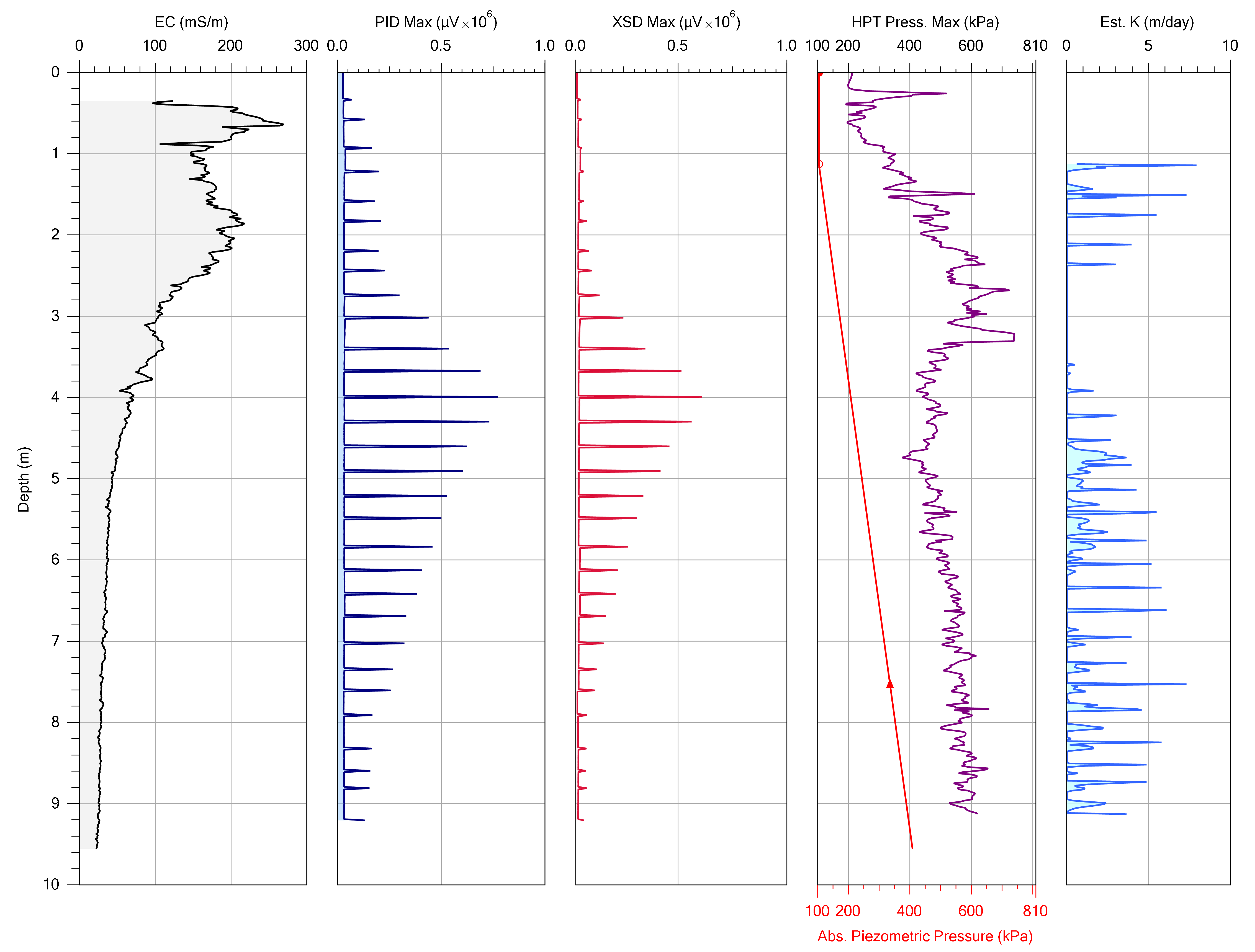
Figure 2 – LLMiHpt Log Showing Depth of Impact, Formation Pressures and Estimated Hydraulic Conductivity
All of the data generated from the LLMiHpt program was then modeled in 2D and 3D to aid in interpretating subsurface conditions along the proposed PRB alignment. This included developing a model of the inferred hydraulic conductivities in the subsurface to identify transport and storage zones (Figure 3) as well as a model of the presence and relative concentration of chlorinated solvents in the subsurface on the client’s property (Figure 4).
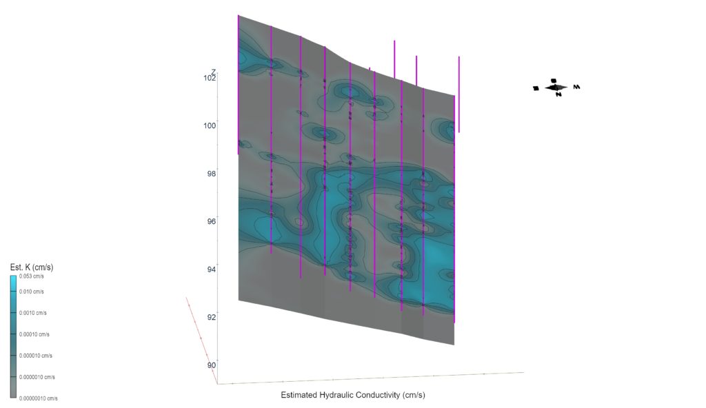
Figure 3 – 2D Model of Estimated Hydraulic Conductivity Along the Proposed PRB Alignment
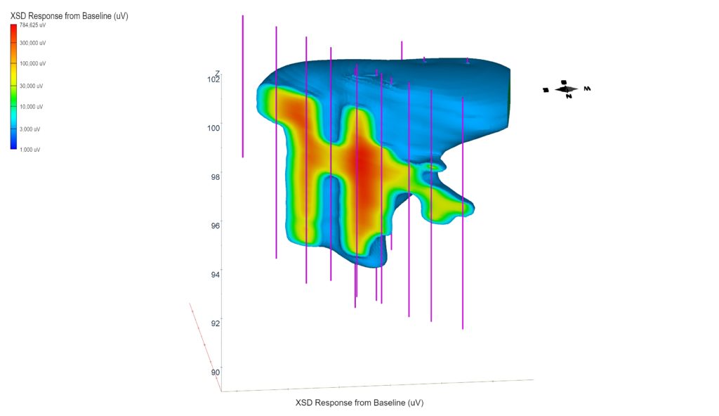
Figure 4 – 3D Model of Inferred Chlorinated Solvent Impacts Extended onto the Client’s Site
In summary, the data acquired from the LLMiHpt survey allowed the following details to be identified in a short amount of time:
- Total required length of the PRB along the property line (shorter than expected)
- Critical contaminant depth intervals (deeper than expected)
- Variability in subsurface permeability (groundwater flow rates)
- Storage and transport zones along the PRB alignment (confining layers)
All of these factors were incorporated in developing the final, optimized PRB design for the site.
At the end of the day, the data generated from the LLMiHpt survey provided much more certainty on the PRB that was needed to address the plume of contaminated groundwater that was migrating onto the client’s property. Had the original design been followed, money would have been wasted in extending the PRB to areas of the site where it wasn’t needed, and the deeper plume would have been completely missed. The refined PRB design resulted in a savings to the client of about 2.5 times the cost of the LLMiHpt survey, while at the same time avoiding failure by ensuring that the entire contaminant plume was captured by the PRB.
Returning to Mr. Pope’s proverb of a little knowledge being a dangerous thing, this case study shows how a LLMiHpt survey can provide more than a little data (knowledge) to avoid the danger of potentially wasting time, effort and costs that can result from inadequate remedial designs. It can also help avoid potential failure of the design!