Albert Einstein, Led Zeppelin and Environmental Remediation
Part II of our Newsletter on the Increasing Uses for High-Resolution Site Characterization
“If I had an hour to solve a problem I’d spend 55 minutes thinking about the problem and 5 minutes thinking about solutions.”
― Albert Einstein
“Many times I’ve wondered how much there is to know.”
from Over The Hills And Far Away – Led Zeppelin
Albert Einstein and Led Zeppelin probably never considered the challenges of environmental contamination. But their thinking is very relevant to site characterization and remediation – basically you should gain a thorough understanding of the problem (know as much as you can know) before working on a possible solution.
Last month we shared an article about how the Ontario Ministry of Environment and Climate Change (MOECC) has prescribed the use of high resolution (High Res) characterization tools to help ensure better delineation at some sites.
A review of the U.S. EPA’s Clu-In, clu-in.org, web pages on High Res shows that they are also supportive of this technology and they specifically point out the following advantages of using these tools to better understand the problem of a contaminated site:
- Characterizing subsurface conditions at a scale unattainable to conventional investigation methods.
- Providing greater confidence that a site is fully characterized by increasing data density.
- Identifying the contaminant mass phases that are present (e.g. NAPL).
- Assessing whether contaminant mass is in a permeable zone or a low permeability zone.
- Enabling more accurate estimation of contaminant mass and volume.
- Improving the cost and performance by minimizing remedial monitoring network needs.
This month we are presenting some real-world examples of the types of enhanced interpretation that can be derived from high resolution site characterization data.
The Use of the HPT to Delineate a PRB Confining Layer
Recently, Vertex was asked to design a Permeable Reactive Barrier (PRB) for a plume of chlorinated solvents in groundwater at a site. Available historic borehole and logs and cross-sections showed that the site had a complex stratigraphy consisting of heterogeneous fill, sand, silt, clay, peat and glacial till units. Due to the importance of ensuring the PRB was keyed into the lower confining layer to vertically intercept the groundwater plume, Vertex employed the Hydraulic Profiling Tool (HPT) at the site.
A series of HPT probe holes was advanced along the proposed alignment of the PRB. The comparison of the data obtained from a representative HPT point with a nearby historic borehole log is presented below.
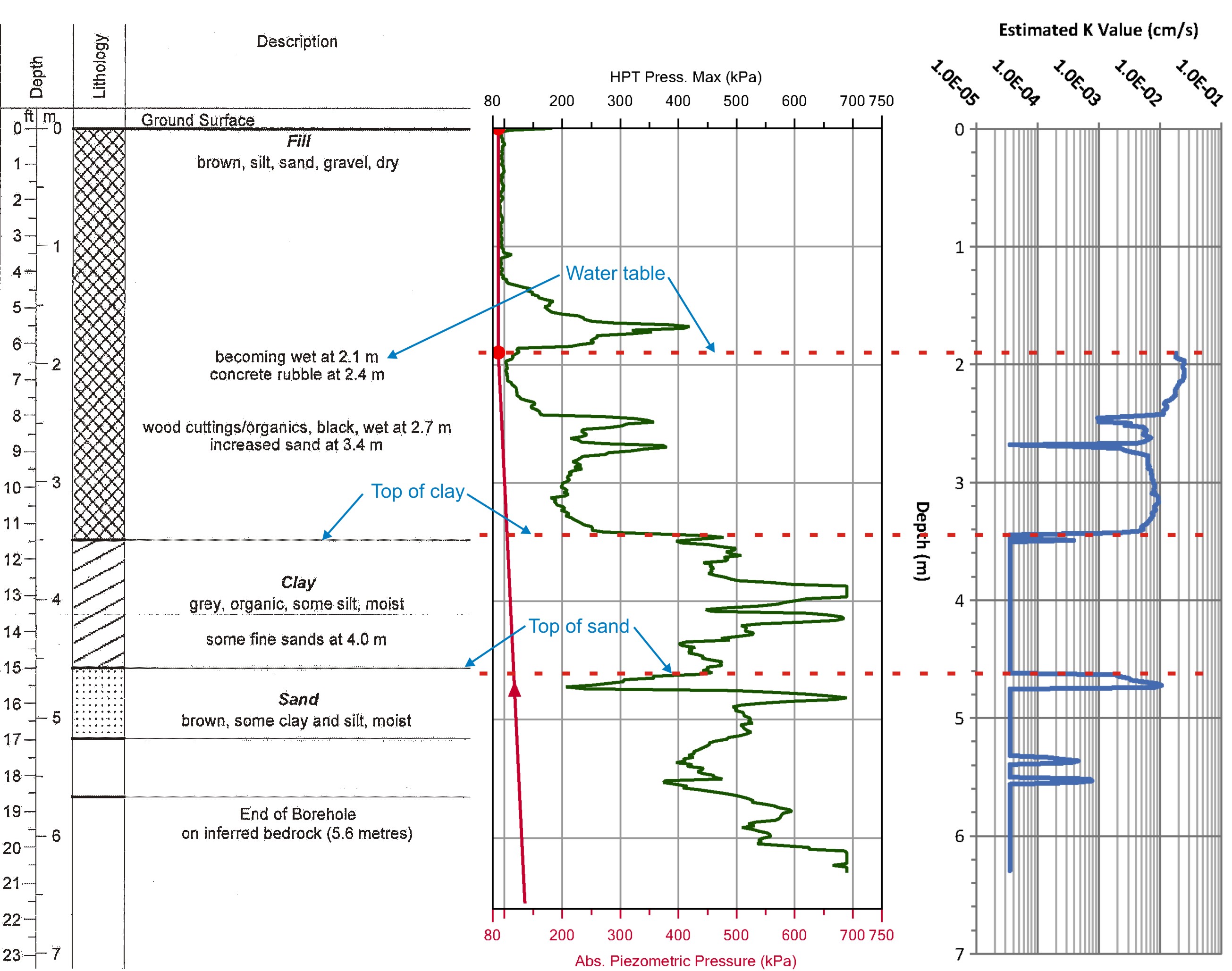
It is clearly apparent that there are some striking similarities and differences between these graphics:
- The borehole log notes that the soils were becoming wet at 2.1 m and the HPT determined that the water table was present at 1.91 m on that date.
- Heterogeneous fill materials transitioned to a lower permeable clay unit at 3.5 m on the borehole log and at 3.44 m on the HPT log.
- A higher permeability sand unit was identified starting at 4.6 m on the borehole log and at 4.63 m on the HPT log.
- The HPT log also identified the presence of two other sand lenses at 5.36 m and 5.53 m that are not shown on the borehole log.
Using the HPT to complete the profiling of site stratigraphy on a centimeter resolution (as opposed to traditional drilling, soil sampling and visual classification methods) allowed a much more precise and effective PRB to be designed. Previously unidentified sand lenses located at depth in the low permeability soils, which might have represented significant contaminant flow paths, were identified by the HPT and taken into account in the final PRB design.
High Res tools are powerful field screening tools because they can “see” impacts not readily observable to technicians in the field. Consider these photos:
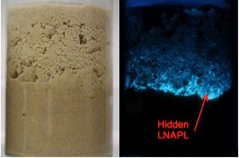
Source: Dakota Technologies
The photo on the left is of a saturated sand sample under visible light – analogous to what a technician would be able to see in the field. The photo on the right is the same sample under ultraviolet light with the diesel fuel free product readily detectable. This is the same technology used by the Laser Induced Fluorescence (LIF) probe to detect free product in-situ.
A practical example of LIF probe in action is shown in the following case study.
Correlation of LIF Response and Soil PHC Concentrations
Site details / background:
- Fuel leak: Petroleum Hydrocarbon (PHC) impacts
- Small area but deep (10 m) PHC & free product
- Multiphase Extraction (MPE) system installed on-site
- High resolution site characterization selected to assist with vertical and horizontal definition of PHCs and free product
Many thousands of data points were collected using the LIF at various locations across the Site. These data were compared to historical soil sample laboratory analytical data. After accounting for outliers in the data resulting from areas that had been remediated, a strong correlation was observed as plotted here:
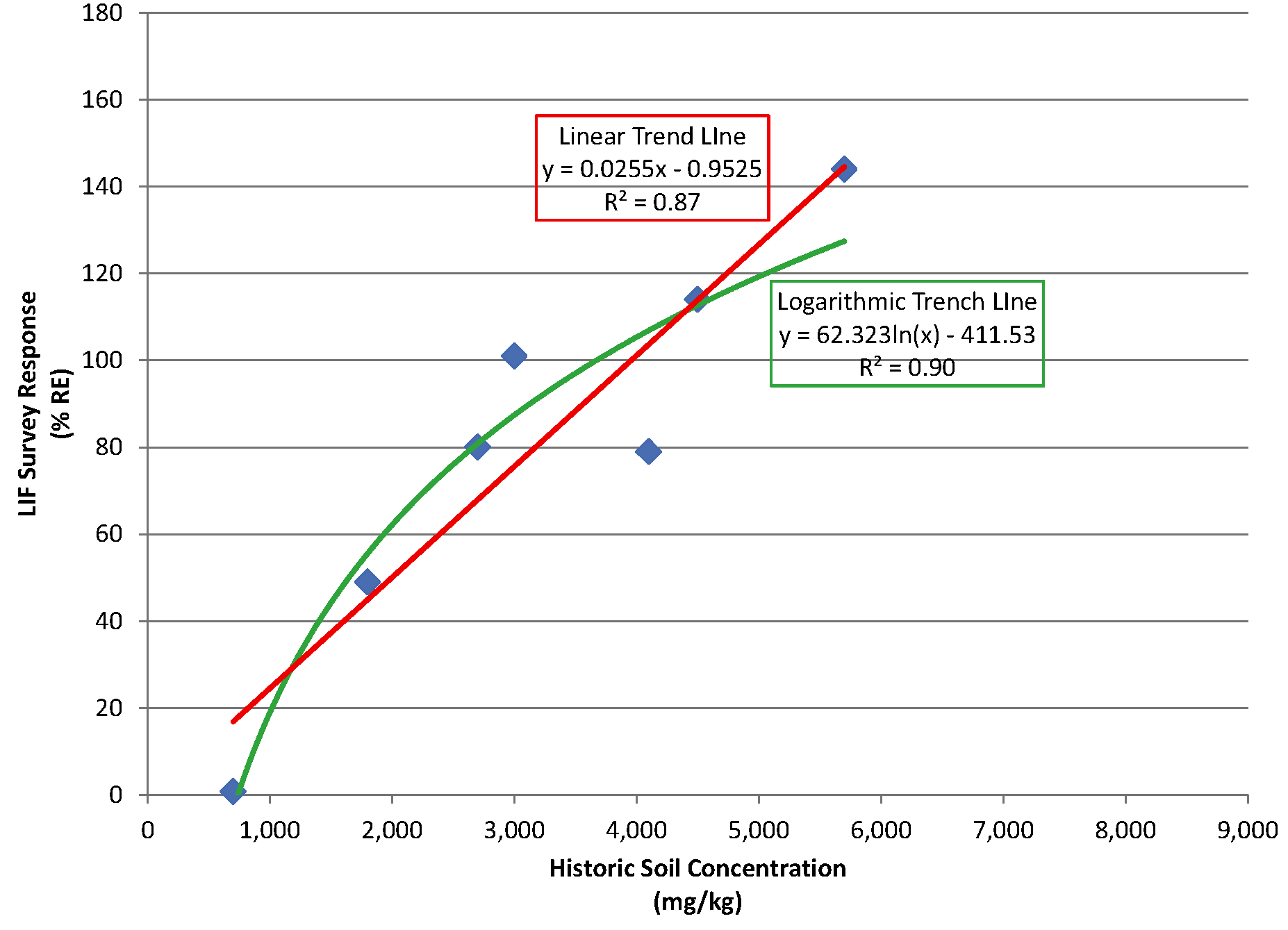
Based on this correlation, a 3D graphical representation of the free phase PHC impacts at depth beneath the site was developed from the LIF data.
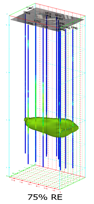
This particular plot shows the detection of PHCs (green) at predicted concentrations just below the acceptable soil quality standards for the site. In other words, it is known with a high level of confidence that the soil impacts were limited to this zone. The area was well defined and vertical delineation was very clear. Based upon these LIF results the client could effectively plan further remediation and/or Risk Assessment, look across the site for PHC seams or pockets, and plan additional MPE and/or excavation with confidence.
In summary, start thinking about site characterization and contaminant delineation like Einstein would: consider using High Res to gain a better understanding of contaminant distribution in the subsurface before starting to think about remedial options.